Algonquin Park
Originally uploaded by Chasing Light Studio ~ Pie's Photography
Log Book:
Tuesday, Oct. 6, 2009
I woke up early to yet another day of overcast skies & constant drizzle. It can really dampen the spirits when you are trying to amp yourself up to head out for some exploration. But that’s just what Tasha & I did – I wasn’t about to sit around camp, we had a big day planned!
We paddled off in the same direction as the day before, but instead of heading up the North York River I veered right at the first portage leading into Scorch Lake from Branch Lake. The plan was to hike up to the look-out, eat some well deserved lunch & continue on to the historic Bruton farmstead.
The paddle across Scorch Lake was very nice, with a few nice campsites along the way – I would consider staying on this lake the next time I visit.
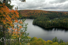
The trailhead for the look-out trail is found at the end of the lake on the southern shore & is marked with flagging tape. The climb up is moderate & fairly short. I got a bit turned around (lost) at what I thought was the top. After the closer inspection of the bear scat (previous image) I continued on but quickly lost sight of any flagging that marked my progress. The area seemed to be the highest point with lots of exposed granite, but with no true look-out. Confused & slightly disappointed I thought to myself out loud “this can’t be it!?”. I started to back track & it was then I noticed my mistake, the scat had me so occupied that I had completely missed the near 90 degree right hand turn in the trail just before the bear poop. I’m glad I continued on as the look-out rates right up there with some of the best scenery that Algonquin has to offer.
Algonquin Park Map:
www.algonquinmap.com/
No comments:
Post a Comment